Showing posts with label Hikes. Show all posts

Sunday, July 29, 2012

Hike #11 - Mt. Rubidoux

As summer vacation winds down, I decided to take the kids to Mt Rubidoux just so they don't get tired of the mountain trails in the Angeles National Forest.  I've been here only once before -- actually riding from Rancho Cucamonga to the top and I figured the kids might enjoy it.  Not the traditional trail hike but 3 miles of paved walking, traffic closed to cars and mostly pedestrians and cyclist.
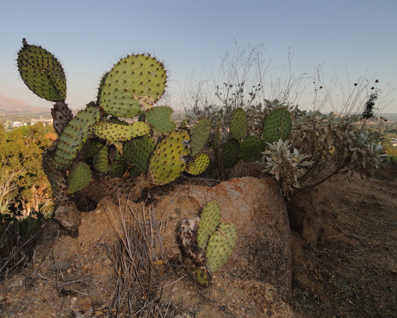
On the east side of the mountain are all these prickly pear cacti growing wild.  On the background is the City of Riverside, with several buildings from the University of California Riverside very visible from the top.  Up here, I really get a good perspective of Riverside and surrounding cities.

At the top, we crossed a small ridge to get a good view of the City of Corona and the Santa Ana hills in the distance.  We explored the top a bit -- walked to the Serra Cross (after the Franciscan Junipero Serra) and the whole time, I was wondering there's really quite a bit of history on this little hill.  As with last week, we consumed all our water by the time we got to the top and it can't cool down soon enough in the IE.  I can only do so many of these hikes in 90 deg heat.

Friday, July 27, 2012

Hike #10 - Mt Wilson Trail, Sierra Madre

I did not intend to hike the Mt. Wilson Trail last Sunday but it was the closest hike to Chantry Flats in Arcadia -- which was so packed I could not even find parking for a mile down the road.  The last time I  hiked from Chantry Flats, there was hardly anyone up there.  Is it because everyone wants to go to Sturtevant Falls?  Has Arcadia grown so much?
As summer winds down, I do wonder if the kids will want to keep on doing these hikes.  We're on track to complete 13 different hikes during their 11-week summer vacation.  We're lucky to have so many trails all within 30 miles of home in Rancho Cucamonga.
It was the hottest hike we've done.  Around 2pm in Sierra Madre, it was 90 degrees and we ran out of drinking water just as we got to our destination -- First Water (sign below) -- which is 1.6 miles from the start of the trail.  Given the extreme heat, that's all we can handle that day.  First Water is just a stream where we played around for a bit but were not able to drink any water.  There was a sign that said Bear Spring - Good Water but we didn't want to take that risk.


Monday, July 16, 2012

Hike #9 - Bear Flats

Our first hike since we got back from Kauai; the 9th one for the summer.  Quite a change from the last hike we did in Kauai -- the muddy Pihea trail; this one is actually close by.  Access to Bear Flats is from Bear Canyon Drive in Mt. Baldy Village.  The actual hike is only 3.5 miles round trip but with the walk from where we parked to where the trail started added another 2 miles.  Overall, not a bad 5.5 miles for a Sunday "stroll". We started tahe hike at 1130am yesterday but most of the uphill trail was shaded from old growth oak trees.  Bear Flats was somewhat of a disappointment other than a sign that says "Backpack Stoves By Permit" only.  This is very, very dry terrain.
JJ had to refresh his head from a cold water stream once we got to Bear Flats.  The hike up was challenging with the elevation starting at around 4500 feet.  I need to confirm but based on my topographic map, it was a 2000 feet elevation gain to Bear Flats from the village.  The hike down was not easy as well with the steep downhill that's not too kind for knees.  We did see several hikers coming down with their hiking poles to help ease the descent, I assume.
This is the view facing southeast.  The village is at the center of the photo and in the far distance, we saw Upland/Rancho Cucamonga.  Overall, the hike was fine but the kids were so used to having some kind of reward at the destination (e.g. waterfall, mud, abandoned mine) that they were somewhat disappointed.  However, I'm absolutely sure they got a decent workout.  We grabbed some tacos for lunch and they wolfed them down like gangbusters.  I just can't believe they have 3 weeks left in this summer vacation and it's been a blast.

Wednesday, July 4, 2012

Hike #8 - Pihea Trail

Two words to describe this trail we did today. Breath-taking. Muddy.  Most of the 3.5 miles we did to Alakai Crossing and back were of the breath-taking variety with amazing views of the Na Pali coast on the west side of Kauai or the greenest of forests we've had the good fortune to hike through.  However, there is a 1/3 mile stretch just after Pihea Vista that is muddy, slippery and fun.  I'm guessing the elevation to be somewhere between 4000 and 5000 feet and I don't think the ground ever dries anytime.  The red Kauai dirt coupled with ever present mist creates the most challenging hike we've done to date.  And the most fun as well.

Below is Sam with the Na Pali coast below.  A good 4000 feet from the ridge where we started the hike.  We heard several helicopters -- the primary way to tour the coast.  The other way is via boat (usually a catamaran) and I'm assuming hiking is the least popular method.  I'm still hoping the kids would like to hike down the coast some time in the future.

We didn't expect mud when we started.  In fact, I started hearing complaints about this hike being boring, as if views of the Na Pali coast was not good enough.  About 1 mile into the hike we started seeing people on their way back with mud on their shoes, legs, shorts, hands, etc.  At that point, I knew we were in for an adventure.  So it became a game of who can hike through the mud without getting any on their leg.  Nobody got any mud on their leg but Sam fell on his butt at least 3 times from slipping.

There were these wooden boards covered with chicken wire that was laid over the forest floor that made trekking across the swamp easier.  At some point in the future, I'd like to do the entire Alakai Swamp trail as well -- which I've read had these boards for most of the hike.  On our way back the car, we were talking about how boring our hikes back in California would be.  These last 10 days were just the most amazing time I've ever had on these islands.  I don't see how we can ever consider any other island for next year's Hawaii trip.

Sunday, July 1, 2012

Hike #7 - Nounou Mountain

I was a little hesitant to do this hike based on what I've read on its dangers but today, I decided we take a conservative approach to the ascent up Nounou Mountain in Kapaa.  The good thing about the hike is that it's literally a mile from where we're staying in town.  There's actually several good things about this hike including the excellent workout I got (1.6 mile with 800 ft elevation gain), a great view of Kapaa, Wailua and Lihue and the nice tropical terrain.  This is Hike #7 for the kids and the 3rd we've done while in Kauai.
This is the 10th year the kids have been going to Hawaii and for the first time ever, I felt that we can actually appreciate much more what the islands have to offer. We tried some hiking in Oahu last year but those were more of the short, tourist walk variety.  Maybe next year, we take on longer adventures like backpacking or day hikes.
Below is a good view of Wailua and Lihue in the far distance.  The eastern trail that we hiked up took over an hour and our shirts were soaked from the humidity.  One of the things I read about is the number of accidents on this hike especially during the wet months.
On our way back, we were fairly relaxed so we started looking for some of these small guava plants for ripe fruit.  Unlike the guavas I grew up eating (typically the size of a ping-pong ball), these are no larger than a small grape.  Sam tried a couple ripe ones and of course, I had several.  There were literally thousands of guavas growing in the wild it seems.

Friday, June 29, 2012

Hike #6 - Cliff Canyon Trail to Waipo'o Falls

This is our second hike in Kauai and started just inside Kokee State Park on the west side of the island.  The hike started at over 3500 feet and the terrain is a lot different from the tropical rainforest hike we did just a couple days ago.  Hiking on the dry side of Kauai made the 3.6 mile loop feel like we were in somewhere in California or Arizona.  (There is good reason to call Waimea Canyon the Grand Canyon of the Pacific.)
 About 1 1/3 mile into the hike, we found out why this is call the Cliff Canyon Trail.  No guardrails or any other barrier between us and a steep 2000+ foot drop to the bottom of the canyon.  The terrain has that American Southwest / desert feel as we scaled the side of the canyon to Waipo'o falls.
Once we got to Waipo'o Falls, we were somewhat disappointed that it wasn't more than a 20-foot waterfall -- given some of the waterfalls in Kauai, this one is more of a stream drop.  The hike back was mostly uphill but the kids were tired enough to sleep all the way down the 15-mile drive to the town of Waimea.
Tired enough to nap but not too tired to skip Brennecke's Beach on the way back.  Our fourth time boogie-boarding/body surfing in as many days was a 2-hr session.  I, we, can get used to this life.

Tuesday, June 26, 2012

Hike #5 - Kuilau Trail, Kauai

We missed our Sunday hike last week since we were literally on a plane most of the day so we had to make it up today.  This is our 5th hike for the summer and it is a short one, about 3 miles in a tropical rainforest also known as the Kuilau Trail.  This is the kids' 2nd hike through a tropical rainforest, the first one being Manoa Falls in Oahu last year. 
Being in this part of Kauai is no different than being in the Jurassic Park movie set -- which happened to have been filmed in Kauai.
I did not expect to see too many hikers on this trail -- and we only saw about 10 others on this humid Tuesday.  Not too many animals either considering the island is littered with chickens.  It's also a change from all the dry hikes we've been doing back home in California.

Sunday, June 17, 2012

Hike #4 - Big Horn Mine Hike

It was a short drive (30 minutes from Rancho Cucamonga) to get there and I had to get a wilderness pass so I can park within Angeles National Forest but it was worth it.  Kids and I spend Father's Day hiking to Big Horn Mine, a 4-mile roundtrip with a total elevation gain of 1000 feet.  Not much total climbing except, the trailhead started at 6565 feet at Vincent Gap.  But the views are definitely worth it.
Several parts of the trail were washed away from rockslides but there was enough to get us through.  Some of the drops were pretty dramatic, which I estimated to be around 500 feet in the worst part, just a quarter mile from the first mineshaft.  Although it was around 95F in Rancho, it felt no more than 70 up here, given the elevation and the mountain breeze.
 Our reward at the end of the trail was this abandoned mining structure which took us 30 minutes to fully explore.  The majority of the steel structured building was gone but there was enough to allow us to climb up to the second mineshaft.  The views were even more stunning once we got there, where the mountain drops about a couple thousand feet below.
Below is Sam climbing up from the structure to get to the platform entrance to the mines.  In contrast to last week's hike to Eaton Canyon where we ran into hundreds of people, the trail to Big Horn Mine had less that a dozen people on it during the 2 hours we were on it.  I'm really hoping to use this high elevation hike as a primer for the kids taking on Mt. Baden-Powell.  We'll see.
Saturday, June 16, 2012

Planning Hike #4

Can't believe this is the kids' 4th week of summer vacation.  Tomorrow will be our 4th hike in as many weeks and I decided we drive a little bit past Wrightwood to do a 4-mile roundtrip hike to see an old mine.  Elevation is well above 6000 ft but the hike itself, according to my topographic map is relatively flat -- yes that's right, an analog map, although I will charge my GPS watch tonight.  We'll make a day of it and explore Wrightwood a little bit.

Tuesday, June 12, 2012

Hike #3 - Eaton Canyon, Pasadena

We used to head out to Eaton Canyon after every major winter storm just to see the water flowing down the riverbed into the reservoir.  When we lived at the house on Harding Avenue, the park entrance was a half mile away and taking into account the 1.5 mile hike, we effectively enjoyed a great 30-foot waterfall about 2 miles away!  That was a benefit I didn't really realize until we moved to Rancho Cucamonga.  As soon as the kids could walk on their own, we would explore the canyon and spend several hours just hanging out.
In the photo above, taken in Nov 2004 shows just how clear the skies over the San Gabriel Mountains could be in the fall.
Last weekend, we decided to hike up to Eaton Canyon, our first hike since moving to Rancho Cucamonga in 2009.  We got a late start and I knew it was going to be crowded but it was worse than I expected.  When we got there, entire families were making the trek on that hot June Sunday afternoon.  Babies, grandmas, kids, dogs, strollers, coolers, bags of potato chips, burgers, etc.  We saw it on the way up, at the destination, and on the way back.  At the waterfall, there must have been over 150 people alone, which surprisingly enough kept the area relatively free of debris and other signs of human presence.
My best memory of Eaton was our hike in Jan 2008 when Maura and I decided to enjoy the winter's day outdoors.  We ran into less than 5 people the entire time and we each picked up these walking sticks along the way.  We must have crossed the water over 20 times as the water level typically rises during the rainy months.  The photo above was taken using my camera on a timer sitting on top of a boulder.

Monday, August 15, 2011

The Loop At North Etiwanda Preserve

I still can't believe this hike starts less than a mile from the house.  The North Etiwanda Preserve loop is an easy 3.2 miles from where the houses end on Day Creek Blvd and Etiwanda Ave. Kids and I finally did the loop yesterday; I'd say it's relatively flat (500 ft elevation gain/loss) and with the nice view of the cities of Rancho Cucamonga, Fontana and Ontario.  Someday, maybe when it cools down, we'll get to the waterfall.  The photo above is on the west end of the loop, about mile 2.5 overlooking a flood control basin.

Sunday, July 31, 2011

They Make Vans Hiking Shoes, Right?

We decided to do a bit of hiking in Oahu last week and this climb to the 1200 ft summit of Koko Head was as bit of a challenge for everyone including JJ -- shown here just a few steps from reaching the top. We started at the baseball field (middle right of photo) and this climb is particularly difficult because you can always see where you're going and it's straight up.  Once there, the views are worth it.  Hanauma Bay Preserve is shown in the photo as well (middle left).
The second hike in as many days was to Manoa Falls, just a couple miles from the University of Hawaii in Manoa.  The challenge was not steepness but humidity and mud.  It was literally a hike through a rainforest and we sweated a lot even though it did not even feel hot.  This photo of a tree root is typical of this hike.
And in both hikes, JJ wore his trusty old Vans skateboarding shoes.  As I was washing it, I was extremely careful to make sure it doesn't fall apart completely.  JJ has this tendency to wear his favorite shoes (and clothes) until they are completely unrecognizable from their original forms.  This was no exception.  Of course, he wore it to the music festival LA Rising last night and he tripped as we were trying to beat the crowds out of the coliseum.  I'm getting him a new pair as soon as humanly possible.